Home Home
  • Home
  • 25 years
  • News
  • Sectors
    • City councils
    • Public authorities
    • Mobility and sustainability
      • Smou
    • Service networks
    • Companies and businesses
    • Logistics
  • Tools
    • Cercalia
    • enMapa
    • Recitty
    • Custom solutions
  • Contact
    • Work with us
Contact

Error message

Deprecated function: Return type of Drupal\google_analytics\Component\Render\GoogleAnalyticsJavaScriptSnippet::jsonSerialize() should either be compatible with JsonSerializable::jsonSerialize(): mixed, or the #[\ReturnTypeWillChange] attribute should be used to temporarily suppress the notice in include() (line 10 of modules/google_analytics/src/Component/Render/GoogleAnalyticsJavaScriptSnippet.php).

A new version of the GISAgua Portal, part of the AGBAR Group, will alert subscribers of the service cuts

Submitted by admin on Wed, 09/09/2015 - 16:29
Image
Agbar

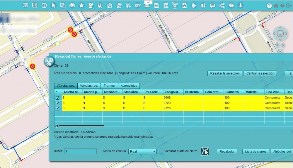
The improvements made in this new version are focused on the evolution of the  closures tool, that increases the performance and capabilities of the previous version, with:

  • The possibility of calculating the closures, whether planned or incidents, both from the office and from the street, through a tablet, the desktop version of GISAgua or the portal itself.
  • A much faster calculation of the area that will be without water service when the cut is made.
  • The possibility of adding the calculation of those areas where there will be subscribers indirectly affected by the cut.
  • The possibility of alerting subscribers affected by email

In addition, we are studying the future possibility of showing the planned measures on Google Maps.

GISAgua is a geographic information system for the management of potable water and sanitation which currently has over 1,800 registered  users from about 750 difeferent municipalities in Spain. It is the GEO component of the AquaCIS products suite  from the Agbar Group, global leader in integrated solutions of water in cities, that operates in 24 countries and serves 25 million people.

SYNECTIC, the technological group company, has a technical team that ensures the correct orientation and usability of the services provides provided by the component.

Categories

Congress and conferences
Transport and infrastructure
NexusTeam
GIS Solutions for City Councils
Smart Mobility
City Councils
Awards
Spatial intelligence
Geolocation
Article
APPS

Related news

pisos
Tue, 02/20/2018 - 00:00
Maps with 3D buildings with apartments and houses on the real estate portal Pisos.com
ematsa
Fri, 02/09/2018 - 00:00
A Touch screen application to inform of field-work water samples
TUS
Mon, 01/15/2018 - 00:00
GIS system of mobility and public transportation of Sabadell
aparkb
Fri, 01/05/2018 - 00:00
Nexus Geographics chosen by B:SM for the development and implementation of the "Where to park for minutes" platform
CONTACT
  • Barcelona Office
    Aragó 264 4, 08007 Barcelona
  • Girona Office
    Joaquim Botet Sisó 6, 17003 Girona
  • Madrid Office
    Paseo de la Habana 9-11, 28036 Madrid
  • +34 93 0172728
    info@nexusgeographics.com
  • TwitterYoutubeLinkedin Instagram
SECTORS
  • City councils
  • Public authorities
  • Mobility and sustainability
  • Service networks
  • Companies and businesses
  • Logistics
NEXUS
  • News
  • Work with us
  • Cercalia
  • enMapa
  • reCitty
  • Contact
OTHERS
  • BusManager
  • Routing Reparto
logo soclogo generalitatLogo eulogo next genenergia renovableENS
aeonorISO
Sello PYME INNOVADORA 11/02/2028
PYME INNOVADORA
Válido hasta el 11 de febrero de 2028
escudo de MEIC 11/02/2028
  • Quality and safety policy
  • Cookies policy
  • Privacity policy
  • Social media policy
  • Legal advice
  • Home
  • 25 years
  • News
  • Sectors
    • City councils
    • Public authorities
    • Mobility and sustainability
    • Service networks
    • Companies and businesses
    • Logistics
  • Tools
    • Cercalia
    • enMapa
    • Recitty
    • Custom solutions
  • Contact
    • Work with us